
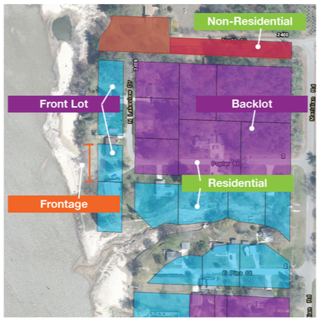
The Four Lakes Special Assessment District (SAD) is an established geographic boundary of waterfront properties along or near the four lakes and “backlot” properties with dedicated (private easement) access. Under Part 307, a county board may determine by resolution that the whole or a part of the cost of a project to establish and maintain a normal legal lake level for an inland lake shall be defrayed by special assessments.
Assessment Appeal
The Midland and Gladwin county boards of commissioners voted on February 6, 2024, to establish a Capital Assessment and 2025-2029 Operations & Maintenance Assessment for the four lakes. On February 20, 2024, Heron Cove Association appealed the decision. You can find documents and FAQ's related to the appeal below.
|
Documents Related to Appeal:
|
Current Status: FLTF filed brief April 16, 2024. Hearing to listen to oral objections scheduled for May 29, 2024. WHEN WILL FINANCING OCCUR WITH THE APPEAL?
It takes approximately 2.5-3 months to process and solicit funds. The financing plan was to have $80 million of municipal financing available in June. If FLTF successfully contests the appeal through the court system, funds would be received from municipal financing three months later. As an example, if the appeal is resolved in July in favor of FLTF, then funds will be available sometime in October. IS FLTF ASKING FOR MORE GRANTS FROM THE STATE OR FEDERAL GOVERNMENT RIGHT NOW?
Asking or seeking grants and receiving grants are two different steps. FLTF is always looking for funds to lessen the burden of the costs. However, to responsibly receive a grant or government allocation, a common requirement is that the organization must not be encumbered with a lawsuit. In addition, a grant for capital expenditures often requires proof of operating revenue to fund the operations. The Operations and Assessment Roll and Capital Assessment Roll are both being appealed. The appeal puts FLTF and the counties in a position where grant funds are unlikely to be distributed until the appeal is resolved in favor of FLTF. WHAT IS EGLE’S EXPECTATION IF THE LAKE LEVELS ARE NOT RESTORED?
In the June 30, 2021, EGLE (Michigan Department of Environment, Great Lakes, and Energy) letter to FLTF, EGLE recognized the Counties’ ownership of the Delegated Authority, and that the four dams were rated as high-hazard potential dams regulated by EGLE. The letter states the following expectations:
|
operations & Maintenance assessmentPays for annual administration, operations and maintenance of the four dams
Timing: December 2022 - December 2024 Amount: $65-$265 Next assessment: December 2025 - December 2029
Amount: $80-$300 |
Capital Improvements AssessmentPays for design and construction of repairs and restoration
Timing: 2024-2064 Amount: $450-$1,800 |
Operations and Capital Assessment Calculation
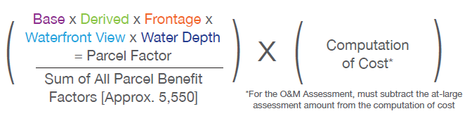
Note: Adjacent lots associated with the same property owner will be assessed.
|

|
|

|
Length of parcel that faces body of water (lake, river, canal, tributary etc.).
|
|
|
Width of waterway perpendicular to shoreline frontage of parcel.
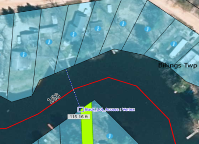
Parcel on canal with 163 feet of water view
|
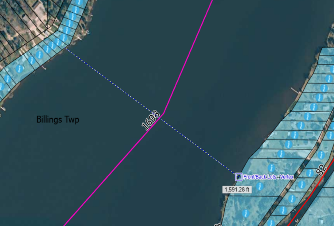
Parcel in wide portion of Wixom Lake with 1,698 feet of water view
|
Estimated water depth 40 feet from shoreline when Part 307 lake levels are restored.
|

|
Four LAkes Special Assessment District faqs
|
Capital Assessment
WHY CAN'T THE GOVERNMENT PAY FOR THE CAPITAL IMPROVEMENTS?
Each county is paying 3% of the Operations & Maintenance Assessment. FLTF, on behalf of the counties, sought and received grants and donations of approximately $60 million from the state, local, and federal government, and private donors to pay for the recovery of the lakes, design and engineering studies, and state permitting. Additionally, $180 million from the State of Michigan grant will cover over 40% of project costs. Over the coming years, through construction and beyond, FLTF will continue to seek grants and other revenue sources to lower the cost of assessments to those in the FL SAD. Will the capital assessment amount remain the same each year?
No. The capital assessment amount will change every year due to the equal principal payment model that will be utilized in the bond and USACE loan. The principal amount will remain the same year-to-year, but the interest amount will decrease as the principal balance is reduced. This leads to the highest annual payment in year 1 and the lowest annual payment in year 40.
To illustrate this concept more clearly, the first-year annual payment will be approximately 15% higher than the average payment and the last payment will be approximately 15% lower than the average annual payment. The below graph summarizes how the annual assessment payment varies year after year per $1,000 average assessment assumption due to the variation in annual payment over the life of the assessment. This assumes a 40-year payment term and 5% interest rate. 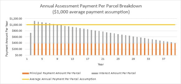
Can I make additional principal payments on the capital assessment or pay the entire capital assessment upfront?
Yes. Capital Assessment principal amount for the property may be paid off at any time, in part or in full. Interest cost impact is a matter of the payment timing. Pre-payments made before the bond issuance will be paid towards principal - there will not be an interest payment.
Payments after the cutoff date for prepay will be paid towards the principal, and a portion of the payment will be for the accrued interest that has accumulated for that portion of the principal. How do I make a principal payment?
How do I know my total principal or payoff amount?
How come my annual Capital Assessment payment estimate multiplied by 40 doesn't equal the total Capital Assessment principal?
Financing has principal and interest components. The principal is what is owed before interest is added to the total Capital Assessment. The average annual payment, which includes interest, is what you will pay over the 40 years of the assessment. Multiplying the total annual payment by 40 equals the total amount you will pay including interest. Similar to a mortgage paid over 30 years, the total of payments is greater than the amount of money borrowed due to interest charged by the lender. Once financing is approved, a property owner can pay off their portion of the Capital Assessment principal at any time. IF I PAY OFF THE PRINCIPAL, AND THE PROJECT DOES NOT COST AS MUCH AS PLANNED, DO I GET A REBATE?
If there were factors such as project performance or new grants that lower the overall project and financing costs, then the property owner obligation is lowered. So yes, if you paid off the principal and there is a “rebate” it would go to the owner of the property at the time. The point being that if you sell your property, any future new obligation or rebate goes to the new owner(s). We do not expect any adjustment. If one occurs at all, it is likely to happen when the project is much further along in the 2025 or 2026 timeframe. What’s the interest rate on the capital assessment?
If FLTF secures a loan from the U.S. Army Corps of Engineers, then the loan would be for 35 years with an interest rate equivalent to 30-year treasury rates plus one basis point. FLTF would be able to refinance at any time. If FLTF secures municipal financing, then the loan would last 40 years and have approximately a 6% interest rate. FLTF would be able to refinance after eight years. Other/Miscellaneous
WHAT HAPPENS TO THE ASSESSMENT IF I SELL MY PROPERTY?
Generally, payment of a special assessment is between the seller and buyer of the property. A seller and buyer may choose to structure the purchase agreement so the buyer assumes the special assessments. At times, special assessments are paid in full at the time of sale (meaning the full amount is deducted from the purchase price). Why did construction costs change so much?
Please take a look a this brief report which summarizes the market conditions and major factors driving the price increase across each of the Four Lakes projects. What happened to the $200M grant from the state?
On March 30, 2022, the State of Michigan appropriation Act 53 was approved. It included a $200 million grant to Four Lakes Task Force, the delegated authority for Gladwin and Midland counties. The grant provided funding for the Four Lakes Special Assessment District for engineering, design, remediation, construction or other applicable resources. Approximately $20 million of the project was used for pre-construction, including design and permitting of the proposed new dams. The remaining $180 million will be applied towards construction costs. This government contribution significantly reduced the amount needed for financing and the amount assessed to property owners in the special assessment district. The estimated reductions in the cost assessed to each property owner are between 50% and 60%. Will Boyce Hydro or the government contribute to project costs?
The Boyce entities are bankrupt with their assets and insurance payments having been distributed to creditors of Boyce or the victims of the flood. While there are still civil actions and lawsuits outstanding, none are likely to yield any funds for the Four Lakes Special Assessment District. Federal, state and local governments, as well as private funders have provided over $245 million for the recovery, design and permitting of the four lakes. $180 million from the State of Michigan will be applied to lower the costs of the assessment. FLTF continues to look for funds to offset the cost burden to property owners, but the reality is that Michigan has 2,500 dams, and there are significant long-terms funds required to maintain them or remove them. With an impounded lake in Michigan, that is not privately owned, an assessment district will usually come with the lake. Does the SAD pay for Flood programs below the Dams?
No, there is a separate program for that which is not under FLTF. We have had over $2.5 million committed from Midland private funders to FLTF - almost all of this is being used for recovery, flood studies or general funds. We are engaged with Midland groups as needed to be aligned in planning. We have coordinated some funds to put rain and flow gauges in a few rivers outside of the Four Lakes scope which is being funding by government grants and Midland-based funding. WHAT ABOUT WEEDS?
Normally aquatic weed management is the responsibility of the Lake Improvement Boards or weed special assessment districts. FLTF has been working with these entities to determine the best path forward to manage weeds and tree growth during this transition period. WHAT AUTHORITY REGULATES DAM SAFETY?
The State of Michigan regulates dam safety. FLTF as the county delegated authority and acting on behalf of the Four Lakes Special Assessment District has the authority to manage the lake levels. I combined my properties. Why Can’t I Find My Combined Properties by Their New Parcel ID Number?
Property combinations made by township assessors in the past few months are tentative, pending final approval in March 2024. Such combinations may not show up as combined parcels on the current FLTF special assessment district maps. Instead, one parcel will have an assessment based on the characteristics of the combined parcels and the other parcel(s) will be blacked out on the map and show a $0 assessment. Once the new parcel combinations receive final approval, the FLTF maps will be updated with the new combination information. |
Assessment Amounts & Methodology
can i still object to my Assessment?
No. Objections were collected leading up to and through the January 15, 2024, public hearing where the FLTF board approved the assessment rolls. On February 6, 2024, the Gladwin and Midland county commissioners approved the assessment rolls. Please see the Dec. 22, 2023, letter mailed to property owners which contains further information. Does my assessment pay for design, construction, repairs and restoration just for my lake/dam?
No. Assessments pay for capital improvements to all four lakes and dams. There was no feasible alternative for a township(s) or lake association to acquire or provide the legal, financial or regulatory oversight to repair, restore or maintain these dams. The dams are hydraulically linked in their design and management. The counties took ownership of the dams to protect the lakes and the benefit and there are significant funds being applied that lower the financial burden to property owners in the SAD. The assessment methodology is applied so that when comparing two parcels with the same benefit, either in the same lake community or two different lakes, they will have the same payment, that includes the distribution of costs offset by grants. WHAT COSTS ARE INCLUDED IN ASSESSMENTS?
Costs are categorized in two ways and will be assessed as follows: operations costs and capital improvement costs. Operations costs pay for operations and management of the lakes during the transition to their normal levels, emergency repairs, the development of operational plans, and long-term, ongoing operations. Capital improvement costs are fixed, one-time expenses to make the dams operable (engineering design, construction and repairs). Payments in connection with capital improvements will not occur until we finalize engineering plans, obtain all permits, receive construction bids, and conduct the Special Assessment hearing. Is the assessment on my winter tax bill for the current year or the next year?
The assessment on your parcel’s winter tax bill is for the current calendar year (i.e., an assessment on the winter 2024 tax bill is for the 2024 assessment). Will the Operations and Maintenance Assessment and the Capital Assessment be shown as separate amounts on my winter taxes?
As they are two separate assessment rolls, they will be shown as two separate line items on a winter tax bill. Does the same methodology apply to the capital improvement assessment?
Yes, we’ll use the same methodology for the capital improvement assessment. Why are the apportionment percentages different for the estimated O&M and Capital assessments?
In addition to the properties within the Four Lakes Special Assessment District, the counties, townships in the SAD and Village of Sanford contribute to operations and maintenance costs through an “at-large” assessment. Their contribution lowers the apportionment amount for property owners which is why the apportionment percentage for the O&M Assessment is slightly lower than the apportionment percentage for the Capital Assessment. The Capital Assessment does not include an at-large assessment on local government units. Are the property lines on the GIS map accurate?
The property boundaries shown on the GIS layers were created by the counties. FLTF uses the same maps to reduce costs. The location your property line as shown on the GIS is not a surveyed depiction of the exact location of your property boundary. It would require a substantial effort on behalf of the counties to construct and maintain a county wide GIS system that meets boundary survey accuracy requirements for every property boundary in the county. The county GIS was developed to assist with administering the property information records for tax and governance purposes. It is not suitable for property boundary disputes. You should contact a professional surveyor for more detailed property boundary information. CAN I COMBINE MY PARCELS?
We are unable to recognize new parcel combination requests after February 1, 2024. Part 307
What is the role of a Special Assessment District?
The Four Lakes Special Assessment District is a special public body established by the 2019 Lake Level Order by Midland County Judge Stephen Carras on behalf of both Gladwin and Midland counties in May 2019. The Four Lakes Special Assessment District consists of lakefront properties as well as backlot properties that have access to the lakes, the boundaries of which were confirmed by the 2019 Lake Level Order after numerous public meetings, and resolutions from the Gladwin and Midland County Boards of Commissioners. The counties have determined that all costs associated with the maintenance of the normal legal levels for the four lakes should be financed by special assessments to the benefitted properties within the Special Assessment District. In other words, the Four Lakes Special Assessment District is the source of funding for the maintenance of the lakes. While there can be other sources, such as government, private and public funding, and perhaps hydropower to offset assessments, the Four Lakes Assessment District is considered the primary source of funding to maintain the lakes. WHO IS IN THE FOUR LAKES SPECIAL ASSESSMENT DISTRICT?
Properties that have access to the lakes through the shoreline, private roads or deeded access. The properties in the Special Assessment District – after public review, notifications and opportunity to appeal – were established in the May 2019 Court Order. WHO GRANTS THE AUTHORITY FOR THE LAKES?
All four lakes (Sanford, Wixom, Smallwood and Secord) are “artificial lakes” created by the damming of the Tobacco and Tittabawassee rivers. The authority to “have lakes” is somewhat complicated and involves an understanding of over 100 years of historical information that led to the formation of the lakes and the relationship with the private dam owner. In May 2019, the Midland Circuit Court entered an order (“2019 Lake Level Order”) establishing the legal levels for each of the lakes in accordance with Part 307, Inland Lake Levels, of the Natural Resources and Environmental Protection Act, 1994 Pa 451, as amended. Part 307 is the exclusive authority for a county or counties to make policy decisions to ensure the establishment and maintenance of the level of an inland lake. Midland and Gladwin counties have directed that all costs associated with the maintenance of the lake levels be paid by special assessments. The 2019 Lake Level Order also established and confirmed the Four Lakes Special Assessment District. The Four Lakes Special Assessment District is a special purpose public body, and the Four Lakes Task Force is the county delegated authority, acting on behalf of the Four Lakes Special Assessment District. What Should Property Owners Know About Part 307?
What are the regulations surrounding how the special assessment is distributed?
Part 307 states that special assessments can be determined based on “benefits derived” to the property owner and that FLTF is responsible for determining the factors that contribute to the derived benefits. In general, there is no specific method of allocating the cost of improvements, except that the method selected must be fair, just, equal and in proportion to the benefits conferred. These benefits include factors like frontage, zoning and property use. Once the assessment amount is established, what is the process for changing it in the future?
If we want to make any major changes to the assessment in the future, it must go through the process again as defined in Part 307. Why is the lake level special assessment based on parcel benefits rather than property value?
In Michigan, lake level special assessments must be based on benefits derived. In addition, the levying and collection of special assessments under Part 307 must conform as nearly as possible to the Michigan Drain Code. What this means is that lake level special assessments are similar to drain assessments, and are based on the benefit to the property, not the owner, and not the taxable value of a home on the property. As in the case of a drain project, FLTF is required to calculate the cost of the lake level project and then assign a percent of that cost to the properties benefiting from the project. When people search the internet about Michigan special assessments they may see rules about other types of assessments that may utilize market value tests. The methodology for lake level special assessments apportions the cost of the project according to the benefit derived. Why aren't river property owners upstream and downstream of the Four Lakes included in the SAD?
Upstream and downstream property owners do not have property that's adjacent to the lakes, nor does their land have deeded access to the lakes. Therefore, like any property that is not adjacent or with access, they receive no direct benefits, and are not part of the Special Assessment District. While there are property owners in the Special Assessment District who feel that other property owners outside the district should be assessed, Four Lakes Task Force nor the counties have any standing, based on Part 307, Inland Lake Levels Act, the physical water flows, and intended use of the dams, to include others in the Special Assessment District. Background Legal Framework The Four Lakes are governed under Part 307, Inland Lake Levels and Part 315, Dam Safety of Michigan's Natural Resources and Environmental Protection Act. The lake boundaries were established by a defined normal (legal) lake level or elevation. River properties upstream of the Secord Lake boundary and downstream of the Sanford Lake (or dam) are not part of the Special Assessment District. The Special Assessment District boundaries are defined by a 2019 court order. Deeded access to properties near the lakes was established in the 1920s and 1930s. Physical Flow of Water The new dam design and regiment of operations of the gates will be "run of the river.” This is documented in the permits. It means that the lake level will remain the same by having the same amount of water flow from the Four Lakes system that flows in. Use of Dams As defined by the Association of State Dam Safety Officials, "The purpose of a dam is to impound (store) water, wastewater or liquid borne materials for any of several reasons, such as flood control, human water supply, irrigation, livestock water supply, energy generation, containment of mine tailings, recreation, or pollution control." The four dams impound the Four Lakes for the purpose of recreation. When restored, the dams/lakes . . .
|
